Geolocate

Salu topographic map

Click on the map to display elevation.

About this map

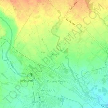
Name: Salu topographic map, elevation, terrain.

Location: Salu, Porac, Pampanga, Central Luzon, 2007, Philippines (14.99884 120.52129 15.03884 120.56129)

Average elevation: 37 m

Minimum elevation: 17 m

Maximum elevation: 59 m

Other topographic maps

Click on a map to view its topography, its elevation and its terrain.

Miyamit Falls

Philippines > Pampanga > Porac

Average elevation: 807 m

Barangay Dolores Plaza

Philippines > Pampanga > Porac

Average elevation: 133 m

Gear up for your next adventure:

🔭Compact Monocular - One-handed bird watching and trail spotting
🔋Lithium AA Batteries - Long-lasting power that performs in extreme cold
🧥Thermal Fleece Jacket - Versatile insulation for changing mountain temperatures
🧴Sunscreen SPF - Broad-spectrum sunscreen for outdoor activities
🥾Lightweight Hiking Shoes - Comfortable shoes for day hikes

As an Amazon Associate, this site earns from qualifying purchases at no extra cost to you.