
Make a donation
Gear up for your next adventure:
As an Amazon Associate, this site earns from qualifying purchases at no extra cost to you.
Mechelse Poort topographic map
Click on the map to display elevation.
Make a donation
Gear up for your next adventure:
As an Amazon Associate, this site earns from qualifying purchases at no extra cost to you.
About this map
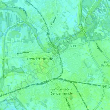
Name: Mechelse Poort topographic map, elevation, terrain.
Location: Mechelse Poort, Dendermonde, Oost-Vlaanderen, 9200, België (51.01253 4.08685 51.05253 4.12685)
Average elevation: 4 m
Minimum elevation: 0 m
Maximum elevation: 7 m
Make a donation
Gear up for your next adventure:
As an Amazon Associate, this site earns from qualifying purchases at no extra cost to you.
Other topographic maps
Click on a map to view its topography, its elevation and its terrain.
Schoonaarde
België > Oost-Vlaanderen > Dendermonde > Dendermonde
Schoonaarde ligt aan de Schelde op een hoogte van 8-9 meter. De bodem is zandig en zandlemig.
Average elevation: 6 m
Sint-Gillis-bij-Dendermonde
België > Oost-Vlaanderen > Dendermonde > Dendermonde
Sint-Gilles-bij-Dendermonde ligt aan de Dender. De zuidgrens van het grondgebied wordt gevormd door de Vondelbeek. Het sterk verstedelijkte grondgebied behoort tot Zandig Vlaanderen en de hoogte bedraagt 4-8 meter.
Average elevation: 4 m
Make a donation
Gear up for your next adventure:
As an Amazon Associate, this site earns from qualifying purchases at no extra cost to you.
Camille Marchantplein
België > Oost-Vlaanderen > Dendermonde > Dendermonde > Sint-Gillis-bij-Dendermonde > Klein-Parijs
Average elevation: 5 m