
Make a donation
Gear up for your next adventure:
As an Amazon Associate, this site earns from qualifying purchases at no extra cost to you.
Wiesmoor topographic map
Click on the map to display elevation.
Make a donation
Gear up for your next adventure:
As an Amazon Associate, this site earns from qualifying purchases at no extra cost to you.
Wiesmoor
On Friday 13 January 1989, a half year after the Ramstein Airshow Disaster, there was a collision of several military jets at low altitude over the Hinrichsfehn area of Wiesmoor. A tornado of the Royal Air Force collided with a squadron of German Alphas Jets of the Jagdbombergeschwader 43 division. One of the German Alpha Jets was seriously damaged but managed to make an emergency landing, the a further Alpha Jet and the Tornado were destroyed, the pilot of the Alpha Jet managed to eject but the two pilots in the Tornado died in the accident. The wreckage from the jets landed near a primary school in South Wiesmoor.
Make a donation
Gear up for your next adventure:
As an Amazon Associate, this site earns from qualifying purchases at no extra cost to you.
About this map
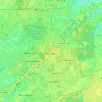
Name: Wiesmoor topographic map, elevation, terrain.
Location: Wiesmoor, Landkreis Aurich, Lower Saxony, 26639, Germany (53.35663 7.64467 53.47241 7.81582)
Average elevation: 9 m
Minimum elevation: 0 m
Maximum elevation: 18 m
Make a donation
Gear up for your next adventure:
As an Amazon Associate, this site earns from qualifying purchases at no extra cost to you.
Other topographic maps
Click on a map to view its topography, its elevation and its terrain.
Make a donation
Gear up for your next adventure:
As an Amazon Associate, this site earns from qualifying purchases at no extra cost to you.