Geolocate

Gemur topographic map

Click on the map to display elevation.

About this map

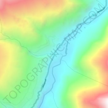
Name: Gemur topographic map, elevation, terrain.

Location: Gemur, Lahul, Lahaul and Spiti, Himachal Pradesh, India (32.59182 77.12650 32.63182 77.16650)

Average elevation: 3,727 m

Minimum elevation: 3,178 m

Maximum elevation: 4,738 m

Other topographic maps

Click on a map to view its topography, its elevation and its terrain.

Chandratal Lake

India > Himachal Pradesh > Lahul

Average elevation: 4,403 m

Suraj Tal

India > Himachal Pradesh > Lahul

Average elevation: 5,007 m

Chandratal Lake

India > Himachal Pradesh > Lahul

Average elevation: 4,403 m

Gear up for your next adventure:

🛰️Satellite Messenger - Emergency communication for areas with no cell service
🌡️Emergency Mylar Blankets - Compact thermal protection for unexpected nights outdoors
🧦Thermal Socks - Warm socks for winter hiking or camping
Camping Groundsheet - Protect your tent from moisture and dirt
🥾Trail Hiking Socks - Comfortable socks to prevent blisters and fatigue

As an Amazon Associate, this site earns from qualifying purchases at no extra cost to you.