Geolocate

Richmond topographic map

Click on the map to display elevation.

About this map

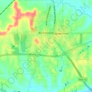
Name: Richmond topographic map, elevation, terrain.

Location: Richmond, Ray County, Missouri, 64085, United States (39.24587 -93.99769 39.29681 -93.93662)

Average elevation: 240 m

Minimum elevation: 216 m

Maximum elevation: 285 m

Gear up for your next adventure:

🥾Trail Running Shoes - Lightweight and durable shoes for trail running
🧢Outdoor Cap - Protective cap for sun and rain during hikes
🚲Heavy Duty Bike Lock - Secure your bike at the trailhead or during stops
🔦LED Headtorch - Bright and durable light for night activities
🥫Freeze-Dried Meals - Lightweight, high-calorie nutrition for multi-day treks

As an Amazon Associate, this site earns from qualifying purchases at no extra cost to you.