
Make a donation
Gear up for your next adventure:
As an Amazon Associate, this site earns from qualifying purchases at no extra cost to you.
Eskoriatza topographic map
Click on the map to display elevation.
Make a donation
Gear up for your next adventure:
As an Amazon Associate, this site earns from qualifying purchases at no extra cost to you.
Eskoriatza
Eskoriatza liegt am Oberlauf des Río Deba ca. 55 km (Fahrtstrecke) südöstlich von Bilbao bzw. ca. 22 km nordöstlich von Vitoria-Gasteiz in einer Höhe von ca. 275 m in den Südhängen des Kantabrischen Gebirges. Das von der ca. 40 km Luftlinie nördlich gelegenen Biscaya beeinflusste Klima ist gemäßigt; Regen (ca. 1066 mm/Jahr) fällt übers Jahr verteilt.
Make a donation
Gear up for your next adventure:
As an Amazon Associate, this site earns from qualifying purchases at no extra cost to you.
About this map
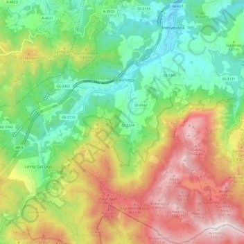
Name: Eskoriatza topographic map, elevation, terrain.
Average elevation: 615 m
Minimum elevation: 229 m
Maximum elevation: 1,187 m
Make a donation
Gear up for your next adventure:
As an Amazon Associate, this site earns from qualifying purchases at no extra cost to you.