
Montrose topographic map
Interactive map
Click on the map to display elevation.
About this map
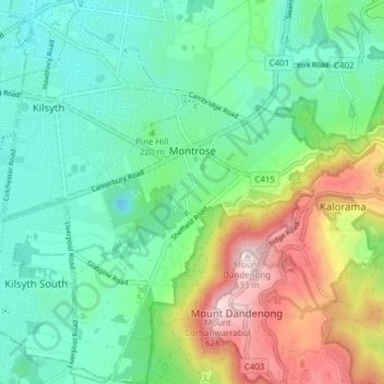
Name: Montrose topographic map, elevation, terrain.
Location: Montrose, Shire of Yarra Ranges, Victoria, 3765, Australie (-37.83486 145.32291 -37.78697 145.37469)
Average elevation: 239 m
Minimum elevation: 66 m
Maximum elevation: 621 m
Other topographic maps
Click on a map to view its topography, its elevation and its terrain.
Mount Dandenong
Australie > Victoria > Montrose
Mount Dandenong, Montrose, Shire of Yarra Ranges, Victoria, 3765, Australie
Average elevation: 429 m