Geolocate

Carbonate topographic map

Click on the map to display elevation.

About this map

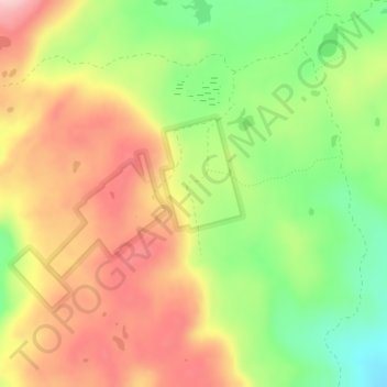
Name: Carbonate topographic map, elevation, terrain.

Location: Carbonate, Garfield County, Colorado, United States (39.73155 -107.35678 39.75155 -107.33678)

Average elevation: 3,339 m

Minimum elevation: 3,233 m

Maximum elevation: 3,439 m

Other topographic maps

Click on a map to view its topography, its elevation and its terrain.

Battlement Mesa

United States > Colorado > Garfield County

Average elevation: 1,806 m

Rifle

United States > Colorado > Garfield County

Average elevation: 1,731 m

Silt

United States > Colorado > Garfield County

Average elevation: 1,695 m

Parachute

United States > Colorado > Garfield County

Average elevation: 1,572 m

Harris Reservoir

United States > Colorado > Garfield County

Average elevation: 2,251 m

Gear up for your next adventure:

🧦Merino Wool Socks - Moisture-wicking comfort for long-distance hiking
🧥Waterproof Hiking Jacket - Protect yourself from rain and wind while hiking
🧴Bear Spray Holster - Quick-access carry for essential Canadian wilderness safety
🔋Emergency Crank Radio - Weather alerts and power without needing batteries
🧭Orienteering Kit - Tools for map reading and navigation in the wild

As an Amazon Associate, this site earns from qualifying purchases at no extra cost to you.