Geolocate

Kasese topographic map

Interactive map

Click on the map to display elevation.

About this map

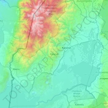
Name: Kasese topographic map, elevation, terrain.

Location: Kasese, Western Region, Uganda (-0.22009 29.71151 0.48223 30.29762)

Average elevation: 1,457 m

Minimum elevation: 778 m

Maximum elevation: 5,017 m

Other topographic maps

Click on a map to view its topography, its elevation and its terrain.

Itebero

Uganda > Rukungiri

Itebero, Rukungiri, Western Region, Uganda

Average elevation: 1,917 m

Kikunda

Uganda > Rwampara

Kikunda, Rwampara, Western Region, Uganda

Average elevation: 1,588 m

Akagera

Uganda > Rakai

Akagera, Rakai, Central Region, Uganda

Average elevation: 1,135 m

Nakawa

Uganda > Kampala > Nakawa

Nakawa, Kampala, Central Region, Uganda

Average elevation: 1,178 m

Jinja

Uganda > Jinja > Jinja

Jinja, Eastern Region, 123, Uganda

Average elevation: 1,170 m

Lake Bisina

Uganda > Katakwi > Kokorio

Lake Bisina, Kokorio, Katakwi, Eastern Region, Uganda

Average elevation: 1,058 m

Iringa

Uganda > Buyende > Iringa

Iringa, Buyende, Eastern Region, Uganda

Average elevation: 1,054 m

Kagera

Uganda > Isingiro

Kagera, Buganza, Isingiro, Western Region, Uganda

Average elevation: 1,304 m

Lake Kwania

Uganda > Dokolo > Kachung

Lake Kwania, Kachung, Dokolo, Northern Region, Uganda

Average elevation: 1,062 m

Lago Alberto

Uganda > Hoima > Hoima

Lago Alberto, Hoima, Western Region, Uganda

Average elevation: 1,076 m

Central Region

Uganda > Central Region

Central Region, Uganda

Average elevation: 1,230 m