
Lintong District topographic map
Interactive map
Click on the map to display elevation.
About this map
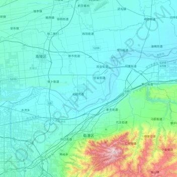
Name: Lintong District topographic map, elevation, terrain.
Location: Lintong District, Xi'an, Shaanxi, 710600, China (34.27906 109.09439 34.65615 109.45610)
Average elevation: 463 m
Minimum elevation: 342 m
Maximum elevation: 1,289 m
Other topographic maps
Click on a map to view its topography, its elevation and its terrain.
Baihe County
China > Shaanxi > Ankang City
Baihe County, Ankang City, Shaanxi, China
Average elevation: 760 m