
Silohi topographic map
Interactive map
Click on the map to display elevation.
About this map
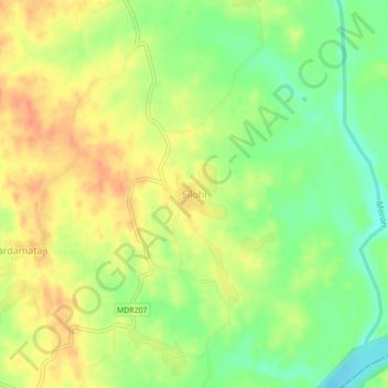
Name: Silohi topographic map, elevation, terrain.
Average elevation: 140 m
Minimum elevation: 116 m
Maximum elevation: 159 m
Other topographic maps
Click on a map to view its topography, its elevation and its terrain.
Bhemai
India > Rajasthan > Galiakot Tehsil
Bhemai, Galiakot Tehsil, Dungarpur District, Rajasthan, India
Average elevation: 187 m
Nadiya
India > Rajasthan > Galiakot Tehsil
Nadiya, Galiakot Tehsil, Dungarpur District, Rajasthan, India
Average elevation: 148 m
Daiyana
India > Rajasthan > Galiakot Tehsil
Daiyana, Galiakot Tehsil, Dungarpur District, Rajasthan, India
Average elevation: 160 m