Geolocate

Gondomar topographic map

Click on the map to display elevation.

About this map

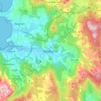
Name: Gondomar topographic map, elevation, terrain.

Location: Gondomar, Vigo, Pontevedra, Galicia, Spain (42.05682 -8.81429 42.16607 -8.68365)

Average elevation: 225 m

Minimum elevation: -1 m

Maximum elevation: 695 m

Other topographic maps

Click on a map to view its topography, its elevation and its terrain.

Redondela

Spain > Galicia > Vigo > Redondela

Average elevation: 188 m

Gear up for your next adventure:

🎒Backpack Rain Cover - External shield to keep your entire pack dry
🥾Mountain Trail Shoes - High-traction shoes for mountain trails
Family Camping Tent - Spacious tent suitable for family camping trips
🚑Survival Whistle - Signal for help across long distances in mountains
🛁Quick-Dry Microfiber Towel - Space-saving towel that dries rapidly on the move

As an Amazon Associate, this site earns from qualifying purchases at no extra cost to you.