
Make a donation
Gear up for your next adventure:
As an Amazon Associate, this site earns from qualifying purchases at no extra cost to you.
Reelsiefen topographic map
Click on the map to display elevation.
Make a donation
Gear up for your next adventure:
As an Amazon Associate, this site earns from qualifying purchases at no extra cost to you.
Reelsiefen
Reelsiefen liegt im Mitte-Westen von Lohmar. Umliegende Ortschaften und Weiler sind Hammerschbüchel im Norden, Höngesberg im Nordosten, Röttgen im Westen, Kreuznaaf, Naaferberg und Ungertz im Südosten, Donrath und Besenbroich im Süden, Wielpütz und Scherferhof im Westen sowie Scheiderhöhe im Nordwesten.
Make a donation
Gear up for your next adventure:
As an Amazon Associate, this site earns from qualifying purchases at no extra cost to you.
About this map
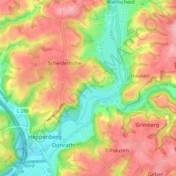
Name: Reelsiefen topographic map, elevation, terrain.
Average elevation: 124 m
Minimum elevation: 59 m
Maximum elevation: 184 m
Make a donation
Gear up for your next adventure:
As an Amazon Associate, this site earns from qualifying purchases at no extra cost to you.