
Lhasa topographic map
Interactive map
Click on the map to display elevation.
About this map
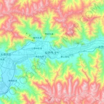
Name: Lhasa topographic map, elevation, terrain.
Average elevation: 4,380 m
Minimum elevation: 3,615 m
Maximum elevation: 5,654 m
Lhasa befindet sich im Transhimalaya-Gebirge. Es liegt etwa in 3600 m Meereshöhe im Tal des Lhasa He (tib.: lha sa gtsang po), einem Nebenfluss des Yarlung Zangbo. Die Stadt liegt an dessen nördlichem Ufer und erstreckt sich heute in west-östlicher Richtung über mehr als 10 Kilometer.
Other topographic maps
Click on a map to view its topography, its elevation and its terrain.