
Make a donation
Gear up for your next adventure:
As an Amazon Associate, this site earns from qualifying purchases at no extra cost to you.
Uelfe IV topographic map
Click on the map to display elevation.
Make a donation
Gear up for your next adventure:
As an Amazon Associate, this site earns from qualifying purchases at no extra cost to you.
Uelfe IV
1484 wird der Ort Uelfe erstmals erwähnt. Ein „Clais in Olve“ wird in einer Darlehensliste für Herzog Wilhelm III von Berg geführt. In der Karte Topographische Aufnahme der Rheinlande von 1825 lautet die Ortsbezeichnung „Cöllnisch Uelfe“. In der Preußischen Uraufnahme von 1840 bis 1843 ist der Ort unter „Holzülfe“ aufgeführt. Erst die historische topografische Karte von 1892 bis 1894 (Preußische Neuaufnahme) nennt die heute gebräuchliche Ortsbezeichnung „Uelfe IV“
Make a donation
Gear up for your next adventure:
As an Amazon Associate, this site earns from qualifying purchases at no extra cost to you.
About this map
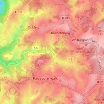
Name: Uelfe IV topographic map, elevation, terrain.
Average elevation: 353 m
Minimum elevation: 241 m
Maximum elevation: 398 m
Make a donation
Gear up for your next adventure:
As an Amazon Associate, this site earns from qualifying purchases at no extra cost to you.
Other topographic maps
Click on a map to view its topography, its elevation and its terrain.
42477
Deutschland > Nordrhein-Westfalen > Oberbergischer Kreis > Radevormwald > Rochollsberg
Average elevation: 359 m