Geolocate

Carei topographic map

Click on the map to display elevation.

About this map

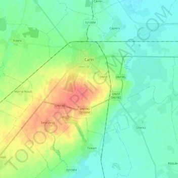
Name: Carei topographic map, elevation, terrain.

Location: Carei, Satu Mare, Romania (47.59571 22.38213 47.72402 22.58786)

Average elevation: 128 m

Minimum elevation: 113 m

Maximum elevation: 164 m

Other topographic maps

Click on a map to view its topography, its elevation and its terrain.

Giurtelecu Hododului

Romania > Satu Mare

Average elevation: 239 m

Sătmărel

Romania > Satu Mare > Satu Mare

Average elevation: 121 m

Cean

Romania > Satu Mare

Average elevation: 186 m

Decebal

Romania > Satu Mare

Average elevation: 120 m

Carei

Romania > Satu Mare

Average elevation: 136 m

Petin

Romania > Satu Mare > Petin

Average elevation: 128 m

Gear up for your next adventure:

📷Outdoor Action Camera - Capture high-elevation views and rugged adventures
🪜Heavy Duty Carabiners - Multi-use clips for securing gear to your backpack
🚲Bike Repair Kit - Essential tools for on-trail mechanical issues
🧢Hiking Sun Hat - Wide-brimmed protection for exposed mountain ridges
👟Sport Hiking Sandals - Breathable footwear for water crossings and camp rest

As an Amazon Associate, this site earns from qualifying purchases at no extra cost to you.