
Charleston topographic map
Click on the map to display elevation.
About this map
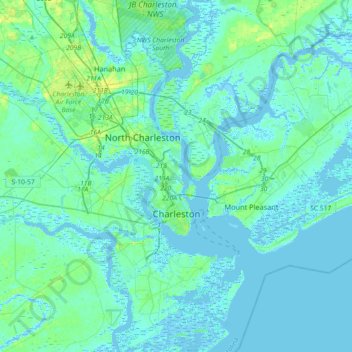
Name: Charleston topographic map, elevation, terrain.
Location: Charleston, Charleston County, South Carolina, United States (32.66851 -80.14385 32.97352 -79.79706)
Average elevation: 4 m
Minimum elevation: -5 m
Maximum elevation: 23 m
Other topographic maps
Click on a map to view its topography, its elevation and its terrain.
Hobcaw Point
United States > South Carolina > Charleston County > Mount Pleasant
Average elevation: 4 m
Saint Andrews Heights
United States > South Carolina > Charleston County > Charleston
Average elevation: 5 m
Pinewood Vista
United States > South Carolina > Charleston County > North Charleston
Average elevation: 9 m
Palmetto Fort
United States > South Carolina > Charleston County > Mount Pleasant
Average elevation: 4 m
Fenwick Crossroads
United States > South Carolina > Charleston County > Charleston
Average elevation: 5 m
Jamestown Estates
United States > South Carolina > Charleston County > James Island
Average elevation: 4 m
Brook Green Meadow
United States > South Carolina > Charleston County > Mount Pleasant
Average elevation: 4 m
Remleys Point
United States > South Carolina > Charleston County > Mount Pleasant
Average elevation: 4 m
Camp Saint Christopher
United States > South Carolina > Charleston County > Seabrook Island
Average elevation: 2 m
North Charleston Wannamaker County Park
United States > South Carolina > Charleston County > North Charleston
Average elevation: 8 m
Forest Park
United States > South Carolina > Charleston County > Charleston > Maryville
Average elevation: 5 m
Liberty Hill
United States > South Carolina > Charleston County > North Charleston
Average elevation: 7 m
Wando Estates
United States > South Carolina > Charleston County > Mount Pleasant
Average elevation: 5 m
Forest Trail
United States > South Carolina > Charleston County > Isle of Palms
Average elevation: 1 m
Saint Andrews Heights
United States > South Carolina > Charleston County > Charleston
Average elevation: 5 m
Ashley Junction
United States > South Carolina > Charleston County > North Charleston
Average elevation: 7 m
Camp Saint Christopher
United States > South Carolina > Charleston County > Seabrook Island
Average elevation: 2 m
North Charleston
United States > South Carolina > Charleston County > North Charleston
Average elevation: 5 m
Northwood Estates
United States > South Carolina > Charleston County > North Charleston > Northwood Estates
Average elevation: 8 m
Country Club Estates
United States > South Carolina > Charleston County > Charleston
Average elevation: 3 m