Geolocate

Panadtaran topographic map

Click on the map to display elevation.

About this map

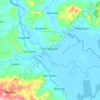
Name: Panadtaran topographic map, elevation, terrain.

Location: Panadtaran, Candijay, Bohol, Central Visayas, Philippines (9.83694 124.46228 9.87186 124.52759)

Average elevation: 40 m

Minimum elevation: -5 m

Maximum elevation: 258 m

Other topographic maps

Click on a map to view its topography, its elevation and its terrain.

Kangkoka Panoramic View

Philippines > Bohol > Candijay > Cambane

Average elevation: 168 m

Gear up for your next adventure:

🛶Waterproof Dry Bags - Keep electronics and clothes dry during river crossings
🔦UV Flashlight - Detect minerals or specific insects in the dark
🧥Waterproof Pants - Keep dry during rainy hiking conditions
🥾Trail Hiking Shoes - Durable shoes designed for rugged trails
🧴Waterproofing Spray - Restore the DWR coating on jackets and tents

As an Amazon Associate, this site earns from qualifying purchases at no extra cost to you.