
Make a donation
Gear up for your next adventure:
As an Amazon Associate, this site earns from qualifying purchases at no extra cost to you.
Brangoly topographic map
Click on the map to display elevation.
Make a donation
Gear up for your next adventure:
As an Amazon Associate, this site earns from qualifying purchases at no extra cost to you.
Brangoly
Brangolí se trouve en Cerdagne, une région de hauts plateaux située dans l'est des Pyrénées, à 1 450 m d'altitude. Le village se situe dans la vallée de la rivière de Brangolí, qui se jette dans l'Angoustrine.
Make a donation
Gear up for your next adventure:
As an Amazon Associate, this site earns from qualifying purchases at no extra cost to you.
About this map
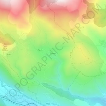
Name: Brangoly topographic map, elevation, terrain.
Average elevation: 1,577 m
Minimum elevation: 1,211 m
Maximum elevation: 2,088 m
Make a donation
Gear up for your next adventure:
As an Amazon Associate, this site earns from qualifying purchases at no extra cost to you.
Other topographic maps
Click on a map to view its topography, its elevation and its terrain.