Geolocate

Tacna topographic map

Click on the map to display elevation.

About this map

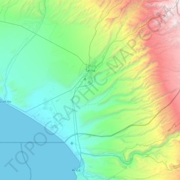
Name: Tacna topographic map, elevation, terrain.

Location: Tacna, Province of Tacna, Tacna, Peru (-18.32231 -70.63856 -17.88983 -69.75469)

Average elevation: 1,084 m

Minimum elevation: 0 m

Maximum elevation: 4,949 m

Other topographic maps

Click on a map to view its topography, its elevation and its terrain.

38

Peru > Tacna > Coronel Gregorio Albarracín Lanchipa

Average elevation: 482 m

Guanaquero

Peru > Tacna > Ilabaya

Average elevation: 3,346 m

Guanaquero

Peru > Tacna > Ilabaya

Average elevation: 3,346 m

LL

Peru > Tacna > Alto de la Alianza

Average elevation: 669 m

159

Peru > Tacna > Coronel Gregorio Albarracín Lanchipa

Average elevation: 461 m

Challamoco

Peru > Tacna > Candarave > Challamoco

Average elevation: 4,665 m

Gear up for your next adventure:

🥾Trail Running Boots - Durable shoes designed for trail running
🧥Thermal Fleece Jacket - Versatile insulation for changing mountain temperatures
🧭GPS Outdoor Watch - Smart watch for navigation and fitness tracking in nature
Family Camping Tent - Spacious tent suitable for family camping trips
🦯Trekking Poles - Reduced impact on joints for steep topographic climbs

As an Amazon Associate, this site earns from qualifying purchases at no extra cost to you.