
Make a donation
Gear up for your next adventure:
As an Amazon Associate, this site earns from qualifying purchases at no extra cost to you.
Trabadelo topographic map
Click on the map to display elevation.
Make a donation
Gear up for your next adventure:
As an Amazon Associate, this site earns from qualifying purchases at no extra cost to you.
About this map
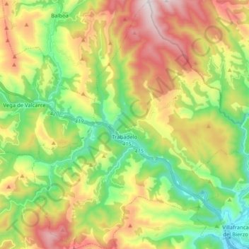
Name: Trabadelo topographic map, elevation, terrain.
Location: Trabadelo, El Bierzo, León, Castille-et-León, Espagne (42.59694 -6.94038 42.71326 -6.80516)
Average elevation: 876 m
Minimum elevation: 479 m
Maximum elevation: 1,444 m
Make a donation
Gear up for your next adventure:
As an Amazon Associate, this site earns from qualifying purchases at no extra cost to you.
Other topographic maps
Click on a map to view its topography, its elevation and its terrain.
Make a donation
Gear up for your next adventure:
As an Amazon Associate, this site earns from qualifying purchases at no extra cost to you.
Villafranca del Bierzo
Espagne > Castille-et-León > El Bierzo > Villafranca del Bierzo > Villafranca del Bierzo
Average elevation: 602 m