Geolocate

Ayah topographic map

Click on the map to display elevation.

About this map

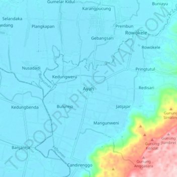
Name: Ayah topographic map, elevation, terrain.

Location: Ayah, Kebumen, Central Java, Java, Indonesia (-7.69971 109.36398 -7.61971 109.44398)

Average elevation: 41 m

Minimum elevation: 0 m

Maximum elevation: 359 m

Gear up for your next adventure:

🔭Compact Binoculars - Lightweight optics for scouting trails and wildlife
💡LED Headlamp - Hands-free illumination for night hiking and camping
🔋Lithium AA Batteries - Long-lasting power that performs in extreme cold
🕯️Camping Lantern - Illuminates your entire campsite with high-efficiency LEDs
🧭GPS Handheld Device - Reliable GPS navigation for outdoor adventures

As an Amazon Associate, this site earns from qualifying purchases at no extra cost to you.