Geolocate

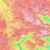
Ranc topographic map

Click on the map to display elevation.

About this map

Name: Ranc topographic map, elevation, terrain.

Location: Ranc, Saint-Étienne-de-Lugdarès, Largentière, Ardèche, Auvergne-Rhône-Alpes, France métropolitaine, 07590, France (44.63327 3.92612 44.67327 3.96612)

Average elevation: 1,097 m

Minimum elevation: 977 m

Maximum elevation: 1,319 m

Other topographic maps

Click on a map to view its topography, its elevation and its terrain.
Gear up for your next adventure:

🐕Hiking Dog Pack - Let your canine companion carry their own water and food
⛺Tent Footprint - Protect tent floor and increase durability
🔭Compact Monocular - One-handed bird watching and trail spotting
🪜Heavy Duty Carabiners - Multi-use clips for securing gear to your backpack
🔦UV Flashlight - Detect minerals or specific insects in the dark

As an Amazon Associate, this site earns from qualifying purchases at no extra cost to you.