Geolocate

Axbiribil topographic map

Click on the map to display elevation.

About this map

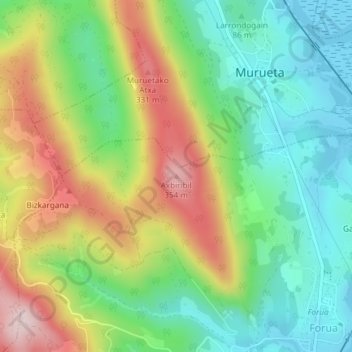
Name: Axbiribil topographic map, elevation, terrain.

Location: Axbiribil, Forua, Vizcaya, País Vasco, 48394, España (43.34456 -2.69173 43.34466 -2.69163)

Average elevation: 141 m

Minimum elevation: -3 m

Maximum elevation: 363 m

Gear up for your next adventure:

👟Trail Running Shoes - Agile footwear for fast-paced topographic exploration
Family Camping Tent - Spacious tent suitable for family camping trips
🧥Thermal Layer - Insulating layer for cold outdoor conditions
Bushcraft Tarp - Versatile emergency shelter or gear protection
🥾Waterproof Hiking Shoes - Durable shoes for wet and rugged trails

As an Amazon Associate, this site earns from qualifying purchases at no extra cost to you.