Geolocate

Medfield topographic map

Click on the map to display elevation.

About this map

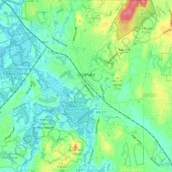
Name: Medfield topographic map, elevation, terrain.

Location: Medfield, Norfolk County, Massachusetts, 02052, United States (42.14862 -71.35218 42.21563 -71.26809)

Average elevation: 57 m

Minimum elevation: 30 m

Maximum elevation: 128 m

Other topographic maps

Click on a map to view its topography, its elevation and its terrain.

Gear up for your next adventure:

🩹Moleskin Blister Pads - Direct protection for painful foot pressure points
🛌Down Sleeping Bag - Superior warmth-to-weight ratio for cold nights
🦟Insect Repellent - Keep mosquitoes and black flies away in wooded areas
🧥Waterproof Jacket - Lightweight rain jackets for hiking and outdoor activities
🔭Compact Monocular - One-handed bird watching and trail spotting

As an Amazon Associate, this site earns from qualifying purchases at no extra cost to you.