Geolocate

Soko topographic map

Click on the map to display elevation.

About this map

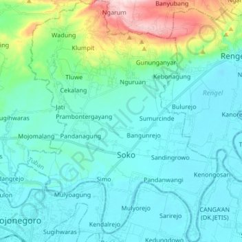
Name: Soko topographic map, elevation, terrain.

Location: Soko, Tuban, East Java, Java, 62372, Indonesia (-7.16509 111.88873 -7.03202 111.99444)

Average elevation: 78 m

Minimum elevation: 7 m

Maximum elevation: 427 m

Other topographic maps

Click on a map to view its topography, its elevation and its terrain.

Jenu

Indonesia > East Java > Tuban

Average elevation: 9 m

Singgahan

Indonesia > East Java > Tuban

Average elevation: 117 m

Grabagan

Indonesia > East Java > Tuban

Average elevation: 287 m

Merakurak

Indonesia > East Java > Tuban

Average elevation: 27 m

Semanding

Indonesia > East Java > Tuban

Average elevation: 46 m

Senori

Indonesia > East Java > Tuban

Average elevation: 57 m

Montong

Indonesia > East Java > Tuban

Average elevation: 208 m

Palang

Indonesia > East Java > Tuban

Average elevation: 6 m

Parengan

Indonesia > East Java > Tuban

Average elevation: 68 m

Tambakboyo

Indonesia > East Java > Tuban

Average elevation: 18 m

Gear up for your next adventure:

🥾Approach Shoes - Shoes designed for climbing approaches and rugged trails
🧴Bear Spray Holster - Quick-access carry for essential Canadian wilderness safety
🧦Hiking Socks - Moisture-wicking and comfortable socks for long hikes
🚲Handlebar Phone Mount - View topographic-map.com live while cycling
🥾Trail Hiking Socks - Comfortable socks to prevent blisters and fatigue

As an Amazon Associate, this site earns from qualifying purchases at no extra cost to you.