
Make a donation
Gear up for your next adventure:
As an Amazon Associate, this site earns from qualifying purchases at no extra cost to you.
Río Pacuare topographic map
Click on the map to display elevation.
Make a donation
Gear up for your next adventure:
As an Amazon Associate, this site earns from qualifying purchases at no extra cost to you.
About this map
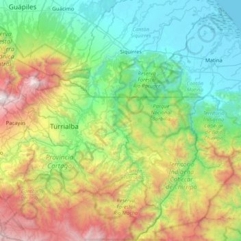
Name: Río Pacuare topographic map, elevation, terrain.
Location: Río Pacuare, Provincia Cartago, 30512, Costa Rica (9.61102 -83.63756 10.23242 -83.27736)
Average elevation: 943 m
Minimum elevation: 0 m
Maximum elevation: 3,382 m
Make a donation
Gear up for your next adventure:
As an Amazon Associate, this site earns from qualifying purchases at no extra cost to you.
Other topographic maps
Click on a map to view its topography, its elevation and its terrain.
Paraíso
Costa Rica > Provincia Cartago > Cantón Paraíso > Paraíso > Paraíso
Average elevation: 1,328 m
Llanos de Santa Lucía
Costa Rica > Provincia Cartago > Llanos de Santa Lucía > Llanos de Santa Lucía
Average elevation: 1,336 m
Tres Equis
Costa Rica > Provincia Cartago > Cantón Turrialba > Tres Equis > Tres Equis
Average elevation: 602 m
Make a donation
Gear up for your next adventure:
As an Amazon Associate, this site earns from qualifying purchases at no extra cost to you.
Guadalupe
Costa Rica > Provincia Cartago > Cantón Turrialba > Tayutic > Guadalupe
Average elevation: 820 m