
Thank you for supporting this site ❤️
Make a donation
Make a donation
Gear up for your next adventure:
As an Amazon Associate, this site earns from qualifying purchases at no extra cost to you.
Currais topographic map
Click on the map to display elevation.
Thank you for supporting this site ❤️
Make a donation
Make a donation
Gear up for your next adventure:
As an Amazon Associate, this site earns from qualifying purchases at no extra cost to you.
About this map
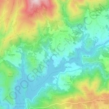
Name: Currais topographic map, elevation, terrain.
Location: Currais, Reigoso, Montalegre, Vila Real, 5470-504, Portugal (41.68631 -7.95938 41.72631 -7.91938)
Average elevation: 816 m
Minimum elevation: 682 m
Maximum elevation: 1,096 m
Thank you for supporting this site ❤️
Make a donation
Make a donation
Gear up for your next adventure:
As an Amazon Associate, this site earns from qualifying purchases at no extra cost to you.