Geolocate

Cross Key topographic map

Click on the map to display elevation.

About this map

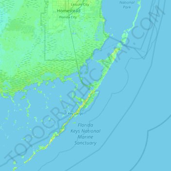
Name: Cross Key topographic map, elevation, terrain.

Location: Cross Key, Monroe County, Florida, 33037, United States (24.87068 -80.72589 25.51068 -80.08589)

Average elevation: 1 m

Minimum elevation: -2 m

Maximum elevation: 13 m

Other topographic maps

Click on a map to view its topography, its elevation and its terrain.

Key

United States > Florida > Monroe County

Average elevation: 0 m

Key Largo

United States > Florida > Monroe County > Key Largo

Average elevation: 1 m

Layton

United States > Florida > Monroe County

Average elevation: 1 m

Key Largo

United States > Florida > Monroe County

Average elevation: 1 m

Duck Key

United States > Florida > Monroe County > Duck Key

Average elevation: 0 m

Fish Hawk Key

United States > Florida > Monroe County

Average elevation: 0 m

Sawyer Key

United States > Florida > Monroe County

Average elevation: 0 m

Tavernier

United States > Florida > Monroe County > Tavernier

Average elevation: 2 m

Crab Key

United States > Florida > Monroe County

Average elevation: 0 m

Gear up for your next adventure:

🥾Light Trekking Boots - Supportive boots for multi-day treks
🪜Heavy Duty Carabiners - Multi-use clips for securing gear to your backpack
🍽️Titanium Camping Spork - Ultralight and indestructible eating utensil
🏕️Camping Hammock - Integrated protection for sleeping between trees
🦟Insect Repellent - Keep mosquitoes and black flies away in wooded areas

As an Amazon Associate, this site earns from qualifying purchases at no extra cost to you.