Geolocate

Thane topographic map

Click on the map to display elevation.

About this map

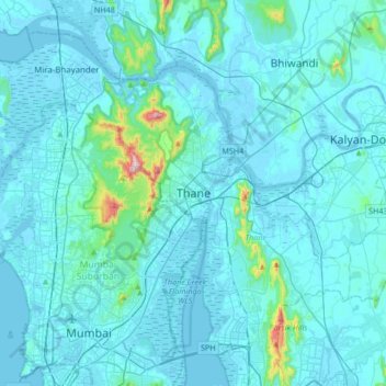
Name: Thane topographic map, elevation, terrain.

Location: Thane, Maharashtra, 400602, India (19.03433 72.81018 19.35433 73.13018)

Average elevation: 30 m

Minimum elevation: -3 m

Maximum elevation: 477 m

Gear up for your next adventure:

🦶Anti-Blister Balm - Prevents friction and hotspots during long ascents
💡Compact LED Flashlight - Powerful and portable flashlight for outdoor use
🥽Outdoor Goggles - Protective eyewear for outdoor activities
🧴Outdoor Sunscreen - High SPF protection for high-altitude UV exposure
🎒Backpack Rain Cover - External shield to keep your entire pack dry

As an Amazon Associate, this site earns from qualifying purchases at no extra cost to you.