Geolocate

Hargrave topographic map

Click on the map to display elevation.

About this map

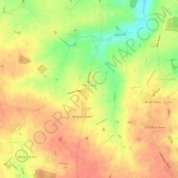
Name: Hargrave topographic map, elevation, terrain.

Location: Hargrave, West Suffolk, Suffolk, England, United Kingdom (52.18868 0.55884 52.22338 0.60768)

Average elevation: 108 m

Minimum elevation: 75 m

Maximum elevation: 126 m

Gear up for your next adventure:

🧭GPS Tracker - Track your location in remote areas safely
🌬️Windproof Camp Stove - Efficient cooking even on exposed mountain peaks
💡LED Headlamp - Hands-free illumination for night hiking and camping
🛌Down Sleeping Bag - Superior warmth-to-weight ratio for cold nights
🚲Bike Repair Kit - Essential tools for on-trail mechanical issues

As an Amazon Associate, this site earns from qualifying purchases at no extra cost to you.