
Thank you for supporting this site ❤️
Make a donation
Make a donation
Gear up for your next adventure:
As an Amazon Associate, this site earns from qualifying purchases at no extra cost to you.
O Pindo topographic map
Click on the map to display elevation.
Thank you for supporting this site ❤️
Make a donation
Make a donation
Gear up for your next adventure:
As an Amazon Associate, this site earns from qualifying purchases at no extra cost to you.
About this map
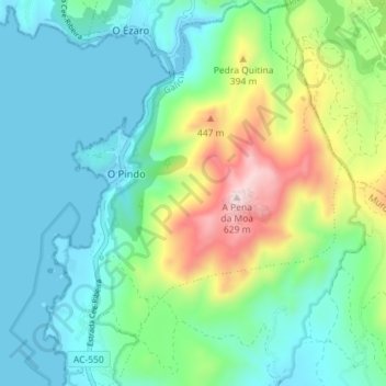
Name: O Pindo topographic map, elevation, terrain.
Location: O Pindo, Carnota, Muros, A Coruña, Galicia, 15296, Spain (42.86306 -9.14936 42.91535 -9.09427)
Average elevation: 159 m
Minimum elevation: 0 m
Maximum elevation: 617 m
Thank you for supporting this site ❤️
Make a donation
Make a donation
Gear up for your next adventure:
As an Amazon Associate, this site earns from qualifying purchases at no extra cost to you.