
Thank you for supporting this site ❤️
Make a donation
Make a donation
Gear up for your next adventure:
As an Amazon Associate, this site earns from qualifying purchases at no extra cost to you.
Quflat `Udhr topographic map
Click on the map to display elevation.
Thank you for supporting this site ❤️
Make a donation
Make a donation
Gear up for your next adventure:
As an Amazon Associate, this site earns from qualifying purchases at no extra cost to you.
About this map
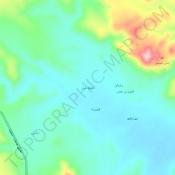
Name: Quflat `Udhr topographic map, elevation, terrain.
Location: Quflat `Udhr, Harf Sufyan District, 'Amran Governorate, Yemen (16.53000 43.99667 16.57000 44.03667)
Average elevation: 1,688 m
Minimum elevation: 1,637 m
Maximum elevation: 1,850 m
Thank you for supporting this site ❤️
Make a donation
Make a donation
Gear up for your next adventure:
As an Amazon Associate, this site earns from qualifying purchases at no extra cost to you.
Other topographic maps
Click on a map to view its topography, its elevation and its terrain.