Geolocate

Interlomas topographic map

Click on the map to display elevation.

About this map

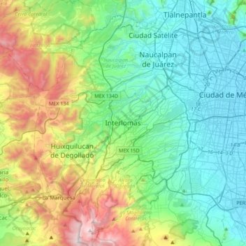
Name: Interlomas topographic map, elevation, terrain.

Location: Interlomas, Huixquilucan, State of Mexico, 52760, Mexico (19.23586 -99.44126 19.55586 -99.12126)

Average elevation: 2,656 m

Minimum elevation: 2,230 m

Maximum elevation: 3,846 m

Other topographic maps

Click on a map to view its topography, its elevation and its terrain.

Gear up for your next adventure:

🧦Crew Hiking Socks - Comfortable socks for long-distance hikes
Camping Groundsheet - Protect your tent from moisture and dirt
🦶Anti-Blister Balm - Prevents friction and hotspots during long ascents
🧥Softshell Jacket - Windproof and breathable jacket for hiking
🧥Ultralight Puffy Jacket - Maximum warmth that packs down to the size of an orange

As an Amazon Associate, this site earns from qualifying purchases at no extra cost to you.