
Make a donation
Gear up for your next adventure:
As an Amazon Associate, this site earns from qualifying purchases at no extra cost to you.
Wangelnstedt topographic map
Click on the map to display elevation.
Make a donation
Gear up for your next adventure:
As an Amazon Associate, this site earns from qualifying purchases at no extra cost to you.
Wangelnstedt
Wangelnstedt liegt unweit nördlich des Sollings. Die Gemeinde befindet sich östlich der Stadt Stadtoldendorf zwischen den Höhenzügen Elfas im Nordosten, Amtsberge im Süden, dem Holzberg im Südwesten und dem Homburgwald im Nordwesten. Die Gemeinde wird vom Oberlauf der Lenne durchflossen.
Make a donation
Gear up for your next adventure:
As an Amazon Associate, this site earns from qualifying purchases at no extra cost to you.
About this map
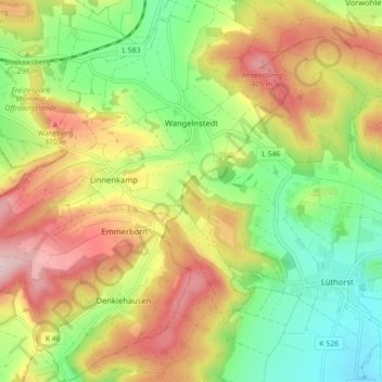
Name: Wangelnstedt topographic map, elevation, terrain.
Average elevation: 280 m
Minimum elevation: 155 m
Maximum elevation: 430 m
Make a donation
Gear up for your next adventure:
As an Amazon Associate, this site earns from qualifying purchases at no extra cost to you.