Geolocate

Mabulo topographic map

Click on the map to display elevation.

About this map

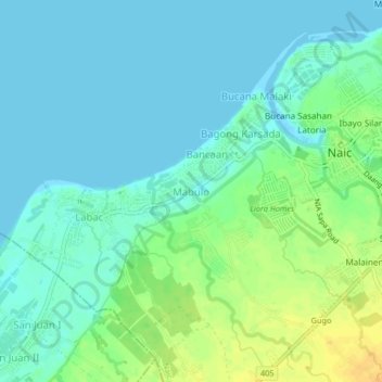
Name: Mabulo topographic map, elevation, terrain.

Location: Mabulo, Naic, Cavite, Calabarzon, 4110, Philippines (14.29509 120.72820 14.33509 120.76820)

Average elevation: 9 m

Minimum elevation: 0 m

Maximum elevation: 27 m

Other topographic maps

Click on a map to view its topography, its elevation and its terrain.

Torres Farm and Resort

Philippines > Cavite > Naic > Sabang

Average elevation: 26 m

Gear up for your next adventure:

🧦Hiking Socks - Moisture-wicking and comfortable socks for long hikes
🎒Hiking Daypack - Lightweight and durable backpacks for day trips and excursions
🔥Emergency Fire Starter - Reliable ignition source for all weather conditions
🥾Hiking Leggings - Comfortable leggings for outdoor activities
🔋Lithium AA Batteries - Long-lasting power that performs in extreme cold

As an Amazon Associate, this site earns from qualifying purchases at no extra cost to you.