
Thank you for supporting this site ❤️
Make a donation
Make a donation
Gear up for your next adventure:
As an Amazon Associate, this site earns from qualifying purchases at no extra cost to you.
Gammerages topographic map
Click on the map to display elevation.
Thank you for supporting this site ❤️
Make a donation
Make a donation
Gear up for your next adventure:
As an Amazon Associate, this site earns from qualifying purchases at no extra cost to you.
About this map
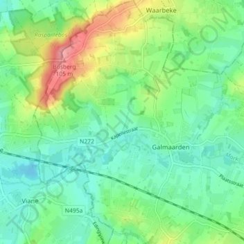
Name: Gammerages topographic map, elevation, terrain.
Location: Gammerages, Hal-Vilvorde, Brabant flamand, Flandre, Belgique (50.73482 3.93104 50.77972 3.98624)
Average elevation: 42 m
Minimum elevation: 12 m
Maximum elevation: 108 m
Thank you for supporting this site ❤️
Make a donation
Make a donation
Gear up for your next adventure:
As an Amazon Associate, this site earns from qualifying purchases at no extra cost to you.