
Make a donation
Gear up for your next adventure:
As an Amazon Associate, this site earns from qualifying purchases at no extra cost to you.
Staller Sattel topographic map
Click on the map to display elevation.
Make a donation
Gear up for your next adventure:
As an Amazon Associate, this site earns from qualifying purchases at no extra cost to you.
Staller Sattel
Der Staller Sattel (italienisch Passo di Stalle) ist ein Gebirgspass in den Ostalpen. Er verbindet das Antholzer Tal (Südtirol) im Westen mit dem Defereggental (Osttirol) im Osten und scheidet die Rieserfernergruppe im Norden von den Villgratner Bergen im Süden. Die Passhöhe liegt auf 2052 m Höhe. Seit dem Inkrafttreten des Vertrags von Saint-Germain 1920 verläuft über den Staller Sattel die Grenze zwischen Italien und Österreich.
Make a donation
Gear up for your next adventure:
As an Amazon Associate, this site earns from qualifying purchases at no extra cost to you.
About this map
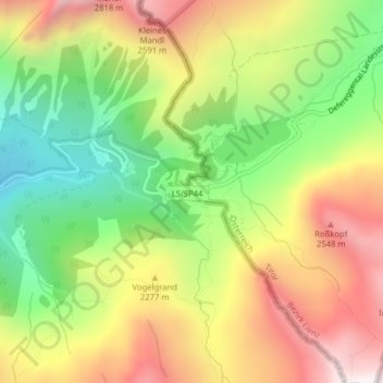
Name: Staller Sattel topographic map, elevation, terrain.
Average elevation: 2,168 m
Minimum elevation: 1,692 m
Maximum elevation: 2,686 m
Make a donation
Gear up for your next adventure:
As an Amazon Associate, this site earns from qualifying purchases at no extra cost to you.