
Make a donation
Gear up for your next adventure:
As an Amazon Associate, this site earns from qualifying purchases at no extra cost to you.
Meudon topographic map
Click on the map to display elevation.
Make a donation
Gear up for your next adventure:
As an Amazon Associate, this site earns from qualifying purchases at no extra cost to you.
Meudon
La commune de Meudon occupe les coteaux de bord de Seine ainsi que les hauteurs avoisinantes. Il en résulte de forts dénivelés et un territoire présentant par endroits de fortes pentes. Ainsi l'altitude varie de 28 m au niveau du fleuve à 179 m sur les hauteurs qui dominent le fond de la vallée. La forêt de Meudon occupe les hauteurs de la commune tandis que la ville occupe les territoires en pente situés en contrebas. Les premières pentes sont occupées par le quartier du Bas-Meudon tandis que le quartier de Bellevue et le centre-ville sont situés à mi-pente. Meudon-la-Forêt forme un quartier isolé du reste de la ville situé sur le plateau de Vélizy-Villacoublay dont l'altitude est comprise entre 168 et 174 m.
Make a donation
Gear up for your next adventure:
As an Amazon Associate, this site earns from qualifying purchases at no extra cost to you.
About this map
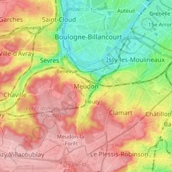
Name: Meudon topographic map, elevation, terrain.
Average elevation: 107 m
Minimum elevation: 23 m
Maximum elevation: 187 m
Make a donation
Gear up for your next adventure:
As an Amazon Associate, this site earns from qualifying purchases at no extra cost to you.