Geolocate

Chamoso topographic map

Click on the map to display elevation.

About this map

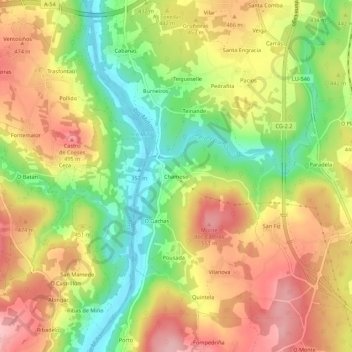
Name: Chamoso topographic map, elevation, terrain.

Location: Chamoso, Paradela, Corgo, Lugo, Galicia, 27163, España (42.91643 -7.52900 42.95643 -7.48900)

Average elevation: 435 m

Minimum elevation: 352 m

Maximum elevation: 512 m

Other topographic maps

Click on a map to view its topography, its elevation and its terrain.

Sabarei

España > Galicia > Lugo > Corgo

Average elevation: 418 m

Folgosa

España > Galicia > Lugo > Corgo

Average elevation: 617 m

Gear up for your next adventure:

🔦LED Headtorch - Bright and durable light for night activities
🧦Hiking Socks - Moisture-wicking and comfortable socks for long hikes
👟Sport Hiking Sandals - Breathable footwear for water crossings and camp rest
🎒Hiking Backpack - Lightweight and ergonomic backpacks for day hikes or multi-day treks
Camping Coffee Maker - Brew fresh coffee anywhere on the topographic map

As an Amazon Associate, this site earns from qualifying purchases at no extra cost to you.