Geolocate

Vitonco topographic map

Click on the map to display elevation.

About this map

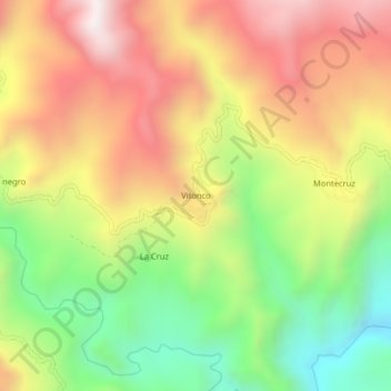
Name: Vitonco topographic map, elevation, terrain.

Location: Vitonco, Páez, Oriente, Cauca, RAP Pacífico, Colombia (2.70243 -76.10239 2.74243 -76.06239)

Average elevation: 2,363 m

Minimum elevation: 1,846 m

Maximum elevation: 2,880 m

Other topographic maps

Click on a map to view its topography, its elevation and its terrain.

Páez

Colombia > Cauca > Páez

Average elevation: 2,607 m

Gear up for your next adventure:

🥾Mountaineering Boots - Supportive boots for climbing and high-altitude hiking
🔋Lithium AA Batteries - Long-lasting power that performs in extreme cold
🔭Outdoor Binoculars - Lightweight binoculars for birdwatching and hiking
🦌Outdoor Trail Camera - Monitor wildlife activity near your favorite spots
🎒Hiking Backpack - Lightweight and ergonomic backpacks for day hikes or multi-day treks

As an Amazon Associate, this site earns from qualifying purchases at no extra cost to you.