Geolocate

Bangana topographic map

Click on the map to display elevation.

About this map

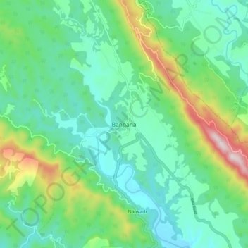
Name: Bangana topographic map, elevation, terrain.

Location: Bangana, Una, Himachal Pradesh, 177041, India (31.59165 76.30003 31.67165 76.38003)

Average elevation: 663 m

Minimum elevation: 499 m

Maximum elevation: 1,129 m

Gear up for your next adventure:

🔭Outdoor Binoculars - Lightweight binoculars for birdwatching and hiking
🚲Handlebar Phone Mount - View topographic-map.com live while cycling
🧦Crew Hiking Socks - Comfortable socks for long-distance hikes
👟Trail Running Shoes - Agile footwear for fast-paced topographic exploration
🔭Compact Binoculars - Lightweight optics for scouting trails and wildlife

As an Amazon Associate, this site earns from qualifying purchases at no extra cost to you.