
Make a donation
Gear up for your next adventure:
As an Amazon Associate, this site earns from qualifying purchases at no extra cost to you.
Garzón topographic map
Click on the map to display elevation.
Make a donation
Gear up for your next adventure:
As an Amazon Associate, this site earns from qualifying purchases at no extra cost to you.
Garzón
Garzón limita por el norte con el municipio de Gigante, por el sur con el municipio de Guadalupe, al suroeste con los municipios de Altamira; por el oriente con el departamento del Caquetá y por el occidente con el municipio de Agrado. Debido a su topografía, se encuentra subdividida en distintas regiones.
Make a donation
Gear up for your next adventure:
As an Amazon Associate, this site earns from qualifying purchases at no extra cost to you.
About this map
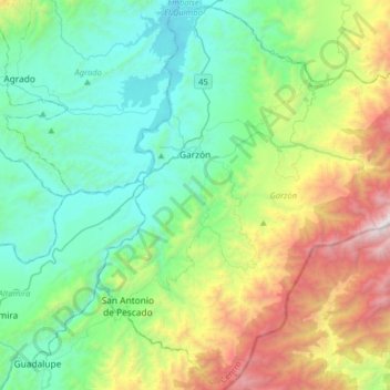
Name: Garzón topographic map, elevation, terrain.
Average elevation: 1,366 m
Minimum elevation: 654 m
Maximum elevation: 3,277 m
Make a donation
Gear up for your next adventure:
As an Amazon Associate, this site earns from qualifying purchases at no extra cost to you.
Other topographic maps
Click on a map to view its topography, its elevation and its terrain.