
Make a donation
Gear up for your next adventure:
As an Amazon Associate, this site earns from qualifying purchases at no extra cost to you.
Buhlbronn topographic map
Click on the map to display elevation.
Make a donation
Gear up for your next adventure:
As an Amazon Associate, this site earns from qualifying purchases at no extra cost to you.
Buhlbronn
Buhlbronn liegt auf knapp 400 Metern Höhe auf den Berglen. Umliegende Orte sind Asperglen, Miedelsbach, Haubersbronn, Schornbach, Streich, Vorderweißbuch und Krehwinkel (im Uhrzeigersinn).
Make a donation
Gear up for your next adventure:
As an Amazon Associate, this site earns from qualifying purchases at no extra cost to you.
About this map
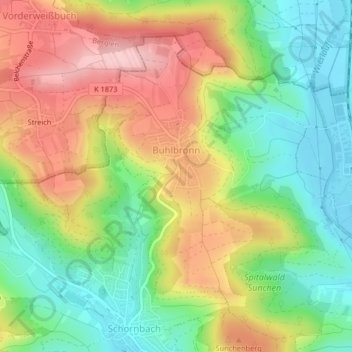
Name: Buhlbronn topographic map, elevation, terrain.
Average elevation: 340 m
Minimum elevation: 260 m
Maximum elevation: 439 m
Make a donation
Gear up for your next adventure:
As an Amazon Associate, this site earns from qualifying purchases at no extra cost to you.
Other topographic maps
Click on a map to view its topography, its elevation and its terrain.
Schornbach
Deutschland > Baden-Württemberg > Rems-Murr-Kreis > Schorndorf > Schornbach
Average elevation: 323 m