Geolocate

Paige topographic map

Click on the map to display elevation.

About this map

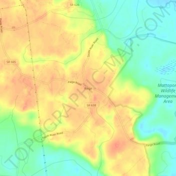
Name: Paige topographic map, elevation, terrain.

Location: Paige, Caroline County, Virginia, 22580, United States (38.05263 -77.43887 38.09263 -77.39887)

Average elevation: 53 m

Minimum elevation: 25 m

Maximum elevation: 76 m

Gear up for your next adventure:

🧭GPS Tracker - Track your location in remote areas safely
🦶Hiking Shoe Insoles - Added support for high arches and long days on feet
🥾Trail Running Boots - Durable shoes designed for trail running
🧰Survival Kit - Essential gear for emergencies in the wilderness
🥾Approach Shoes - Shoes designed for climbing approaches and rugged trails

As an Amazon Associate, this site earns from qualifying purchases at no extra cost to you.