Geolocate

Chemperi topographic map

Click on the map to display elevation.

About this map

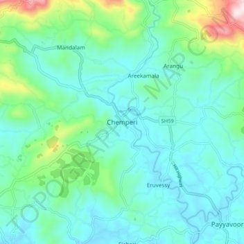
Name: Chemperi topographic map, elevation, terrain.

Location: Chemperi, Taliparamba, Kannur district, Kerala, 670632, India (12.05582 75.50711 12.13582 75.58711)

Average elevation: 137 m

Minimum elevation: 12 m

Maximum elevation: 652 m

Gear up for your next adventure:

🧣Evaporative Cooling Towel - Beat the heat during intense summer climbs
🥾Hiking Leggings - Comfortable leggings for outdoor activities
🦟Insect Repellent - Keep mosquitoes and black flies away in wooded areas
🛶Kayak Accessories - Essential gear for safe and fun kayaking adventures
🍽️Titanium Camping Spork - Ultralight and indestructible eating utensil

As an Amazon Associate, this site earns from qualifying purchases at no extra cost to you.