
Saint-Chély-d'Aubrac topographic map
Interactive map
Click on the map to display elevation.
About this map
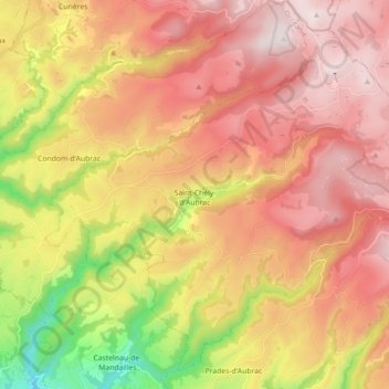
Name: Saint-Chély-d'Aubrac topographic map, elevation, terrain.
Average elevation: 991 m
Minimum elevation: 412 m
Maximum elevation: 1,433 m
Saint-Chély-d'Aubrac et Aubrac sont les deux étapes aveyronnaises de l'Aubrac qui mènent à la vallée du Lot. On quitte Aubrac à 1 300 mètres d'altitude et, en 7 kilomètres, on arrive à Saint-Chély-d'Aubrac à 800 mètres d'altitude, puis on sort de l'Aubrac par Saint-Côme-d'Olt à 400 mètres d'altitude environ, à une quinzaine de kilomètres.