
Gaschet topographic map
Interactive map
Click on the map to display elevation.
About this map
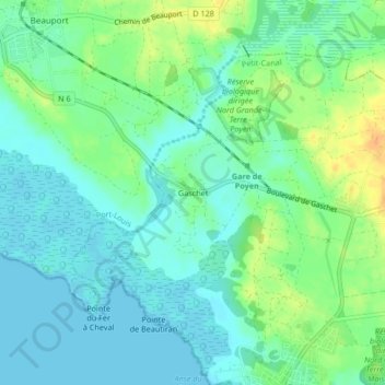
Name: Gaschet topographic map, elevation, terrain.
Average elevation: 11 m
Minimum elevation: 0 m
Maximum elevation: 35 m
Other topographic maps
Click on a map to view its topography, its elevation and its terrain.
Baobab
France > Guadeloupe > Petit-Canal > Les Mangles
Baobab, Chemin du Baobab, Les Mangles, Petit-Canal, Pointe-à-Pitre, Guadeloupe, 97131, France
Average elevation: 32 m
Les Mangles
France > Guadeloupe > Petit-Canal
Les Mangles, Petit-Canal, Pointe-à-Pitre, Guadeloupe, 97131, France
Average elevation: 31 m