
Make a donation
Gear up for your next adventure:
As an Amazon Associate, this site earns from qualifying purchases at no extra cost to you.
Schmitshausen topographic map
Click on the map to display elevation.
Make a donation
Gear up for your next adventure:
As an Amazon Associate, this site earns from qualifying purchases at no extra cost to you.
Schmitshausen
Schmitshausen liegt auf der Sickinger Höhe. Die Entfernung zur Stadt Zweibrücken beträgt 15 km. Zu Schmitshausen gehören zusätzlich die Wohnplätze Am Ochsenberg und Hellborner Hof. Die Wallhalb bildet größtenteils die östliche Gemeindegrenze. Nachbargemeinden sind – im Uhrzeigersinn – Wallhalben, Herschberg, Reifenberg, Winterbach und Biedershausen. Vor Ort nimmt sie von recht die Brechersklamm auf.
Make a donation
Gear up for your next adventure:
As an Amazon Associate, this site earns from qualifying purchases at no extra cost to you.
About this map
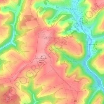
Name: Schmitshausen topographic map, elevation, terrain.
Average elevation: 329 m
Minimum elevation: 252 m
Maximum elevation: 384 m
Make a donation
Gear up for your next adventure:
As an Amazon Associate, this site earns from qualifying purchases at no extra cost to you.