
Thank you for supporting this site ❤️
Make a donation
Make a donation
Gear up for your next adventure:
As an Amazon Associate, this site earns from qualifying purchases at no extra cost to you.
Selce topographic map
Click on the map to display elevation.
Thank you for supporting this site ❤️
Make a donation
Make a donation
Gear up for your next adventure:
As an Amazon Associate, this site earns from qualifying purchases at no extra cost to you.
About this map
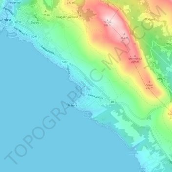
Name: Selce topographic map, elevation, terrain.
Average elevation: 84 m
Minimum elevation: -1 m
Maximum elevation: 378 m
Thank you for supporting this site ❤️
Make a donation
Make a donation
Gear up for your next adventure:
As an Amazon Associate, this site earns from qualifying purchases at no extra cost to you.
Other topographic maps
Click on a map to view its topography, its elevation and its terrain.
Općina Baška
Kroatien > Gespanschaft Küstenland-Bergland
Seit 1910 wird jedes Jahr am zweiten Sonntag im August das Fischerfest von Baška (Ribarski dan) gefeiert. Höhepunkt ist ein Wettrennen im Ziehen von Fischernetzen an den Strand.
Average elevation: 84 m